
ARKANSAS, USA — Tropical Storm Francine is churning in the Gulf of Mexico. As we get to Wednesday, Sept. 11, it could very well become at least a Category 1 hurricane.
Francine is expected to make landfall along the Louisiana coast sometime Wednesday. From there, it will make its way northeast, affecting states like Arkansas, Mississippi, Alabama, Tennessee, Kentucky, Missouri, and north through parts of the Midwest.
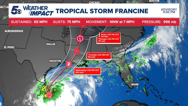
Forecasting tropical weather is all dependent on where the current estimated track lands. Tropical tracks can change from day-to-day, and have major impacts on the forecast. The 5NEWS Weather Team will be following the track of Francine throughout the week.


What should Arkansans expect?
Francine is expected to have a much larger impact in the Delta and Northeast Arkansas for most of Thursday. By the time it reaches the state, it should lose enough energy to be downgraded to a disturbance, but significant rainfall and strong winds should be expected for some.
Francine should have little to no impact on Western Arkansas and the Arkansas-Louisiana-Texas region, outside of a few stray showers, extra cloud coverage, and cooler temperatures.
Central Arkansas should expect a moderate amount of rainfall throughout Thursday, with estimated rainfall amounts anywhere between 1 inch and 3 inches of rainfall. Wind gusts up to 30 mph will be possible, but winds will weaken as it travels further north.
Eastern Arkansas is expected to have the highest impact from Francine where frequent rain and gusty winds will be possible.
Higher amounts of rainfall should be expected from Wednesday night through Friday morning. Latest projections are anywhere from 3 inches to 5 inches of rainfall, which can cause flooding in low-lying areas.
Latest trend
Updated: Tuesday, September 10th
Some good news for Arkansans, Francine looks to be trending even further eastward. We've dropped the potential rainfall amounts a bit, because Francine has taken a much more eastern track. Central and Eastern Arkansas still have the greatest potential to see widespread rainfall, throughout the day Thursday.
Northwest Arkansas and River Valley, may not get any rainfall at all from Francine. Some extra cloud coverage and cooler temperatures are almost guaranteed, while rain chances are very low. New model data is suggesting that we may only get a few scattered showers Thursday.
Watch 5NEWS on YouTube.
Download the 5NEWS app on your smartphone:
Stream 5NEWS 24/7 on the 5+ app: How to watch the 5+ app on your streaming device
To report a typo or grammatical error, please email KFSMDigitalTeam@tegna.com and detail which story you're referring to.
