

TAMPA, Fla. — Tropical Storm Helene is just shy of becoming a hurricane as it approaches the Gulf of Mexico, according to the National Hurricane Center.
The NHC has issued hurricane and storm surge warnings for parts of Florida's Gulf Coast, including the Tampa Bay area, ahead of potential impacts from the storm. It is expected to become the season's next hurricane sometime Wednesday before reaching major hurricane strength on Thursday.
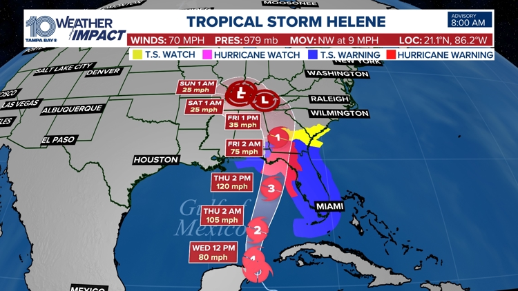
As of the latest advisory, Tropical Storm Helene is about 60 miles east-northeast of Cozumel, Mexico. It's moving at 9 mph with maximum sustained winds of 70 mph. Once winds reach 74 mph, it'll be designated as a hurricane.
"Helen's large size will likely cause an extensive area to be affected by the storm's hazards," the NHC wrote.
On Thursday, Helene is expected to "rapidly strengthen" into a major hurricane, a Category 3 or higher, ahead of landfall.
Timing: Late Wednesday - early Friday
"On the forecast track, the center of Helene will pass near the northeastern coast of the Yucatan Peninsula this morning, move
across the eastern Gulf of Mexico on later today and Thursday, and reach the Big Bend coast of Florida late Thursday," the NHC wrote.
Late Wednesday is when the first rain bands arrive and severe weather is possible.
Thursday, the system will be parallel to Tampa Bay, passing our area and bringing us a surge. Thursday will be the day with the most severe impacts from the storm, with bands of rain and wind. The surge begins later in the day.
Early Friday, our winds shift out of the southwest as the system leaves our area. Flooding and surge will be the major concern. Conditions return to normal on Saturday with typical showers and heat.
Impacts:
Surge: Pinellas, Hillsborough, and Pasco counties could see 5-8 feet, while northern counties could see 6-10 feet of storm surge
Rain: 4-8 inches possible
Wind: 45-55+ mph sustained winds
Severe Weather: Isolated tornadoes possible, a level 1 risk
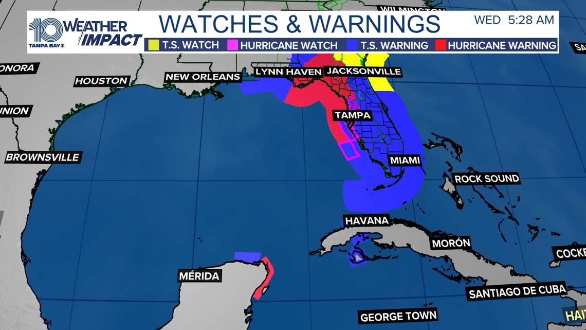
A storm surge warning has been issued for:
- Indian Pass southward to Flamingo
- Tampa Bay
- Charlotte Harbor
A hurricane watch has been issued for the Gulf Coast of Florida from Englewood to the Anclote River, including Tampa Bay.
A hurricane warning has been issued from Anclote River to Mexico Beach, Florida.
A tropical storm watch has been issued for the Flagler/Volusia County Line northward to the Savannah River.
A tropical storm warning has been issued for:
- Dry Tortugas
- All of the Florida Keys
- The Florida west coast from Flamingo to Anclote River, including Tampa Bay
- West of Mexico Beach to the Walton/Bay County Line
- The Florida east coast from Flamingo northward to the mouth of the St. Mary's River
- Lake Okeechobee

While there is still some uncertainty, models are in better agreement that the system will strengthen while moving northward over the Gulf of Mexico. Although it is too soon to specify the exact location and magnitude, areas along the Florida Gulf Coast should prepare for potential impacts from storm surge, heavy rainfall and strong winds.
Now is the time to make sure your hurricane kit is ready and up to date.
10 Tampa Bay is also monitoring a wave off the west coast of Africa for possible development. This tropical wave is bringing no threat to land or Florida at this time.
We will continue to provide the latest information through your 10 Tampa Bay hurricane headquarters.